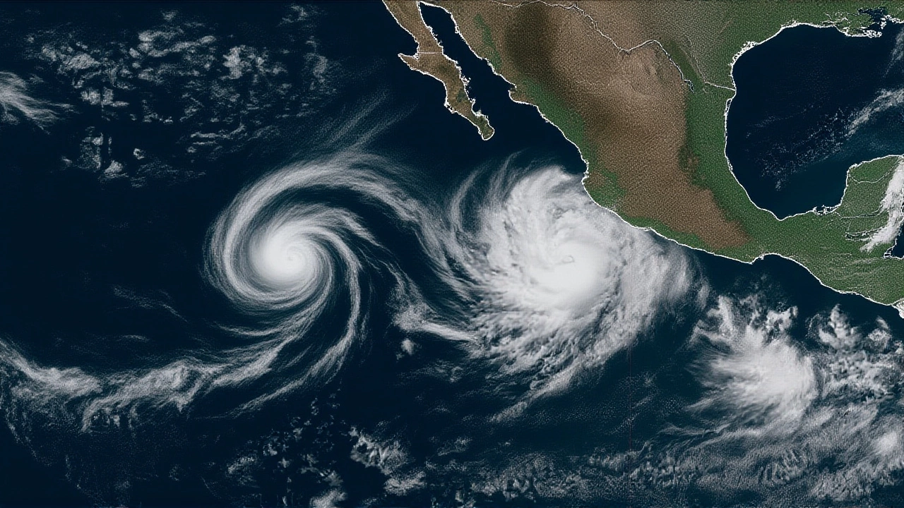
When Hurricane Priscilla began churning off the western shore of Mexico on Wednesday, meteorologists warned that the storm was poised to swing northward, putting Southern California on alert for a bout of thunderstorms later this week.
The first public alert came from Henry DiCarlo, a veteran forecaster at KTLA. In a concise video posted to the station’s YouTube feed at 6:12 p.m. PT, DiCarlo explained that the cyclone would "spin off Mexico’s coast before turning north," potentially delivering scattered showers and a "real chance of thunderstorms" over Los Angeles County on Oct 9‑10.
That brief rundown echoed a broader set of warnings released earlier that morning by the Associated Press. Their dispatch, carried by the New Haven Register, noted that while Priscilla tracked along the Pacific rim, a separate system—Tropical Storm Jerry—was fighting for space in the Atlantic, underscoring how busy the global tropics have become this season.
What’s happening now
Data from the U.S. National Oceanic and Atmospheric Administration (NOAA) show that Priscilla’s central pressure has dropped to 982 mb, a sign the storm is intensifying. The agency’s GFS model projects a steady northward drift at 12‑15 mph, keeping the cyclone just offshore of the Baja California Peninsula through Sunday, Oct 12.
Meanwhile, the Global Disaster Alert and Coordination System (GDACS) issued an alert on Oct 8 warning of "heavy rainfall and strong winds" for the peninsula and for central‑western Mexican states such as Jalisco, Colima and Michoacán. The same alert flags the risk of flash flooding in low‑lying communities and the potential for landslides along the steep coastal cliffs.
- Current max sustained winds: 85 mph (Category 1)
- Projected peak intensity by Oct 12: 100‑110 mph (Category 2)
- Rainfall totals for Baja California: up to 5 inches in 24 hrs
- Expected thunderstorm activity for Southern California: 30‑40 % chance on Oct 9‑10
- Potential storm surge for coastal towns: 2‑3 ft above normal
Why the northward turn matters
Pacific hurricanes rarely venture as far north as the U.S. West Coast. The last comparable event was Hurricane Linda in 1997, which brushed the Santa Barbara shoreline but never produced significant rain. Priscilla’s trajectory is unusual because a persistent high‑pressure ridge over the eastern Pacific is currently steering storms toward the Mexican mainland instead of out into open water.
The twist, as climate scientists point out, is that warmer sea‑surface temperatures in the southern Gulf of California have been extending the “fuel line” for storms, allowing them to maintain strength longer than they historically have. Dr. Elena Morales, a climatologist at the University of California, Irvine, told local media that “the combination of a strong ridge and an unusually warm Pacific is a perfect recipe for a storm that can cross the border and still have bite.”
Forecasts from the experts
On Oct 6, The Watchers AG—the Swiss firm behind the disaster‑monitoring site Watchers.news—predicted Priscilla would reach Category 2 strength by the end of the week. Their analyst, Luca Bianchi, wrote, “If the storm stays over water until Thursday, the ocean heat content should be enough to push winds into the 100‑mph range.”
NOAA’s own hurricane specialist, Emily Chan, echoed that sentiment in a brief interview with ReliefWeb. She said, “We’re watching for a possible landfall on the north‑west tip of the peninsula, but even a glancing blow could dump several inches of rain across the region.”
KTLA’s DiCarlo, however, stressed the uncertainty. "We’re looking at a ‘chance’ of thunderstorms for SoCal, not a certainty. The models are still debating whether the moisture corridor will stay intact as the storm moves north."

Potential impacts across the border
For Mexico, the immediate concerns are flash floods in valleys of Sinaloa and Sonora, plus wind‑driven damage to power lines in the fishing towns of La Paz and Loreto. Local civil protection agencies have pre‑positioned sandbags and issued evacuation notices for low‑lying neighborhoods along the western coast of Baja California Sur.
In the United States, the primary threat is scattered thunderstorms that could bring brief heavy rain, gusts up to 45 mph, and a heightened fire‑weather risk later in the week if the system weakens. The National Weather Service in Los Angeles has raised the outlook to “Elevated” for flash‑flood watches on Oct 9‑10, especially in the foothills of the San Gabriel Mountains.
Transportation officials are also on standby. The California Department of Transportation (Caltrans) announced that “certain coastal highways may see reduced visibility and slick surfaces,” and crews are ready to deploy sand‑abrasive trucks if needed.
What’s next: tracking the storm
The next 48 hours will be decisive. The European Centre for Medium‑Range Weather Forecasts (ECMWF) model suggests a slight eastward jog on Oct 10, which could keep the bulk of the storm’s rain over the ocean while still feeding moisture into Southern California’s inland valleys.
Regardless of the exact track, experts agree that residents should stay tuned to local alerts, keep an emergency kit handy, and avoid low‑lying washes after any thunderstorm. As DiCarlo summed up, “We’ve got a front‑row seat to a rare weather event—let’s watch it responsibly.”
Frequently Asked Questions
How likely are thunderstorms for Southern California on Oct 9‑10?
Current ensemble models give a 30‑40 % probability of measurable rain and gusts above 35 mph in Los Angeles County on Oct 9‑10. The chance rises if Priscilla’s moisture plume stays connected to the southern California air mass.
What areas in Mexico are most at risk?
The western coast of the Baja California Peninsula, especially the states of Baja California Sur and Baja California, face the highest risk of heavy rain and wind. Inland states such as Sinaloa, Sonora, Jalisco and Michoacán may see flash‑flooding in river valleys.
Will Hurricane Priscilla become a Category 2 storm?
Both NOAA’s official forecast and The Watchers AG’s analysis suggest a strong likelihood of Priscilla reaching Category 2 strength (96‑110 mph sustained winds) by Oct 11‑12, assuming sea‑surface temperatures remain above 28 °C.
What should residents do to prepare?
Keep a basic emergency kit (water, food, flashlight, batteries), secure loose outdoor items, and monitor local weather alerts. In flood‑prone areas, avoid driving through washed‑out roads and consider moving valuables to higher ground.
How does this storm compare to past Pacific hurricanes that affected the U.S.?
It’s the first time since Hurricane Linda (1997) that a Pacific system has been projected to bring measurable thunderstorm activity to the Los Angeles area. Most Pacific hurricanes either stay offshore or weaken dramatically before reaching U.S. latitudes.